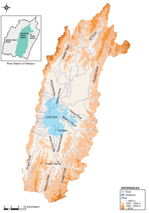
The hill areas of Manipur constituting catchments of Loktak and associated wetlands fall within Manipur River Basin covering an area of 6,872 sq km and representing 31% of the total geographical area of the state.
The basin is characterized by the presence of several shallow and highly vegetated wetlands, locally called Pat, in the central and southern part of Manipur Valley. The wetlands are located in the interfluvial areas as different tributaries, and hill streams connect with the main river channel. The presence of depressions along the river channel, a semi impervious substrate, constricted outflow at Ithai, and a sudden rise in riverbed downstream Ithai at Sugnu create conducive conditions for maintenance of this extensive wetland regime.
These lakes covered about 4.95% (340 sq. km as observed in the Survey of India Topo Map, 1970) of the entire basin area. The important wetlands include Loktak, Pumlen, Lamjao, Khoidum, Kharung, Ikop, and Waithou. Loktak Lake is the largest lake covering 61% of the identified wetland regime. These wetlands are essentially floodplain wetlands of Manipur River interconnected through a complex network of drainage systems.
These wetlands account for approximately 16% of the entire water available in the basin and hence play an important role in the management of water resources in the basin. These floodplain wetlands absorb floodwater during monsoon and are used for agriculture during dry seasons. The wetlands support rich biodiversity, particularly fishery resources. Overall 45 villages and 29 towns are located in and around these wetlands. More than 3 lakh people depend on the wetlands and their resources for their sustenance.
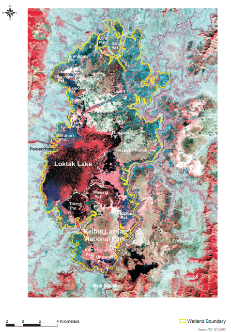
The LWC is a complex of shallow highly vegetated wetlands located in the southern part of Manipur Valley along Manipur River. Spanning between 24.40° to Con 24.72 latitudes and 93.76ºto 93.990 longitudes, the wetlands are located in the interfluvial areas as different tributaries, and hill streams connect with the main river channel. Presence of depressions along the river channel, a semi impervious substrate, constricted outflow at Ithai and a sudden rise in riverbed downstream Ithai at Sugnu create conducive conditions for maintenance of this extensive wetland regime, locally called pat areas. The margins of LWC are diffuse and merge on the exterior with fish farms and rice fields, with small hillocks marking the boundary on the southern end.
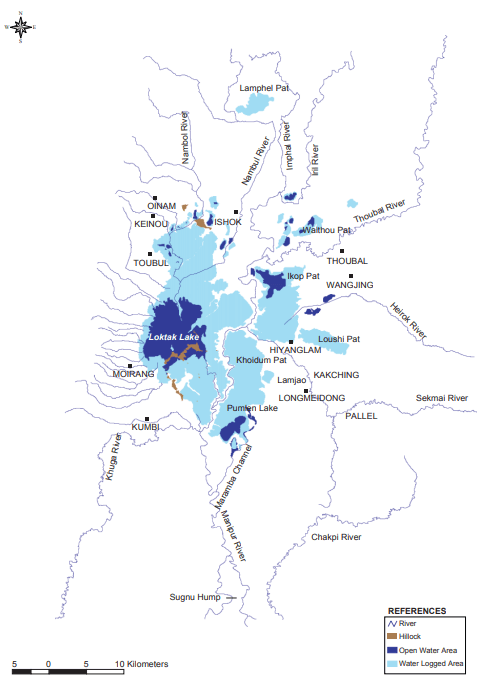
Wetlands constitute 6.8% of the total land area of the Manipur River Basin. The important wetlands locally called pats are – Loktak, Lamphel, Waithou, Ikop, Kharung, Lousi, Khoidum, Lamjao, and Pumlen. The Loktak Lake is the largest pat within the Manipur River basin covering 61% of the total identified wetlands of Manipur. About 20 small and large pats including Loktak, Takmu, Ungamen, Laphupat, Thammumacha, Khulak, Yena, Sana pat, Utra pat, and Tharopokpi are part of the Loktak Lake which are quite distinct during the lean period.
During the rainy season, most of these pats become contiguous and merge under one sheet of water but can be distinguished separately during the dry season at 766 m above MSL. The wetlands covered an area of 340 sq. km in 1970 which has increased to 469 sq. km as estimated in 2002 after the construction of Ithai barrage (Maps 5 and 6). These wetlands play an important role in providing livelihood support to the people food, fodder, fuel, timber, medicines, and other products. They also harbour rich biodiversity and are of great cultural importance to the people of Manipur.

The wetlands of Manipur River Basin are essentially floodplain wetlands. People living in and around the wetlands have wisely used these wetlands for agriculture and fisheries before the construction of hydraulic structures and other water resources development projects. These wetlands through the provisioning of fisheries, aquatic vegetation, and other resources support the livelihoods of a large population living in and around them. The periodic inundation bringing nutrient-rich sediments ensured highly productive agriculture and thus served as the lifeline of the region.
Loktak Lake is considered the lifeline of the people of Manipur due to its importance in their socio-economic and cultural life. It is the largest natural freshwater lake in the northeastern region and plays an important role in providing ecological and economic security to the region. A large population living in and around the lake depends upon its resources for their sustenance. The lake is rich in biodiversity and has been designated as a Wetland of International Importance under Ramsar Convention in 1990. The Keibul Lamjao National Park located in the southern part of the lake is a unique floating wildlife reserve and is the refuge of the highly endangered brow-antlered deer, locally called Sangai. The lake has also been the breeding ground of several riverine fishes and continues to be a vital fisheries resource. It supports a significant population of migratory and resident waterfowl. Loktak Lake is located between 930 46′ and 930 55′ E and from 240 25′ to 240 42’N is a floodplain wetland of Manipur River, which is flooded by its lateral flows as well as backflow of water from Sugunu hump. Further, the confluence of several rivers, particularly Chakpi, is responsible for the inundation of large areas. The lake earlier used to experience large fluctuations in the water level during the year and several pats with the Loktak were distinct during the low water phase and merged into one sheet of water during high floods. The commissioning of Ithai barrage in 1983 has brought about drastic changes in the character of the wetland from fluctuating water levels to more or less constant water levels. The lake is oval-shaped with a maximum length and width of 32 km and 13 km respectively. The depth of the lake varies between 0.5 and 4.6m with an average recorded at 2.7m. The lake covers an area of 287 sq km which is mainly dictated by the maintenance of the water level at Ithai at 768.5 m above MSL. There are 14 hills located in the Lake varying in size and elevation and appear as islands in the southern part of the lake. The most prominent among these are Sendra, Ithing, and Thanga islands.
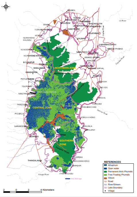
The characteristic feature of Loktak is the presence of floating islands, locally called phumdis. They are a heterogeneous mass of soil, vegetation and organic matter at various stages of decomposition. Phumdis occur in various sizes and thicknesses, occupying almost half of the lake area. Southern portion of Loktak Lake (south of Thanga, Ithing and Sendra islands) forms the Keibul Lamjao National Park, which is a unique floating wildlife national park in India. The park covers an area of 40 sq. km. out of which approximately 15 sq. km is covered by thick phumdis constituting the core area of the National Park. The park is the natural habitat of the most endangered ungulate species, the brow-antlered deer. The lake is an important source of water, fisheries and vegetation providing sustenance to a large population dependent upon lake resources for their sustenance. The lake water is used for irrigation, domestic purposes and power generation. The Lake vegetation is harvested for use as food, fodder, fiber, fuel, handicrafts and medicinal purposes. National Hydro Electric Power Corporation (NHPC) is an important beneficiary using lake water for power generation with a total installed capacity of 105 MW. Loktak with its several islands located inside the lake and surrounded by floating phumdis of different geometrical shapes makes it a unique destination for tourism. Based on its rich biodiversity and socio economic importance, Loktak Lake has been designated by India as a Wetland of International Importance under Ramsar Convention in 1990. It is also included in the list of priority wetlands identified by the Government of India for intensive conservation and management purposes.
Sign Up for our
Newsletter
NEWSLETTER


BOOKS


Loktak Development Authority
The Secured Office Complex
2nd Floor, North Block AT-Line
Near 2nd MR Gate
Imphal(W) Manipur – 795001
Phone No: (0385) 2448563
Fax No: (0385) 2448563
Email: gfsharma2@gmail.com